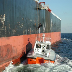
Maritime pilots play a critical role in our nation’s economy. These outstanding shiphandlers guide large vessels through busy waterways to help those ships safely navigate to their destination ports. Virginia pilots help vessels including cargo ships, tankers, and cruise ships reach their destinations safely by boarding those ships from a smaller boat and then navigating them in to port.
Weather conditions greatly affect their job—from the often dangerous transfer from small boat to large vessel, to the operation of the large vessel as they guide it through Chesapeake waters into ports including Norfolk and Richmond. Data from CBIBS buoys is used daily by Virginia pilots like Ben Schill, who checks conditions at the First Landing buoy often because it’s in an area of high traffic for these large vessels.
“Our radar tower watchstanders use the data to facilitate safe boarding of pilots. It can take up to 30 minutes for a ship’s crew to rig a boarding ladder, so having accurate sea state knowledge is invaluable,” said Schill. “The First Landing buoy is ideally located on the north side of Lynnhaven Anchorage where, at times, more than 20 large bulk carriers may be anchored and is close enough to the Pilot Boarding Area off of Cape Henry to provide very accurate wave height and direction data."
Watchstanders in the Cape Henry Radar Tower and in the Dispatch Office at Lynnhaven Inlet monitor computers that constantly display real-time data from CBIBS buoys and other NOAA services including the National Weather Service and PORTS (Physical Oceanographic Real-Time Service). CBIBS data is available to pilots on the go, too.
“All of our pilots carry portable laptops with internet access on board ships and can access the data. Some pilots use smartphones that can access the data online when they are onboard ships or pilot boats. The CBIBS website is also linked on our internal vessel movement website. Between the Maryland and Virginia Pilot Associations, more than 120 professional mariners are aware of the valuable data CBIBS provides to pilot boarding operations at the entrance of the largest estuary in the United States,” Schill described.
When NOAA was deciding where to locate the tenth CBIBS buoy, NOAA representatives asked people in the Norfolk/Virginia Beach area for input.
“The Mid-Atlantic Navigation Manager, based in Norfolk, reached out to our pilot association to introduce the concept of the CBIBS system and to look for input from local professional mariners. They were looking for the best locations for the buoys where both commercial and recreational interests would benefit,” Schill explained. “Outreach from NOAA helped the Virginia Pilots realize what a tremendous resource CBIBS buoys are."
Schill believes the buoys provide data useful to boaters well beyond the pilots. He emphasized, “The accessibility takes the guesswork out of planning a day on the water. Boaters can simply check the observed sea state conditions before they leave home or before launching."
As you might guess, pilots love the water, and while they spend countless hours on the water while on duty, many like to boat and spend time on the water in their free time as well. CBIBS observations come in handy for them then, too!


